
Dosya:2010 Maule earthquake intensity USGS.jpg

Bu önizlemenin boyutu: 510 × 599 piksel. Diğer çözünürlükler: 204 × 240 piksel | 612 × 719 piksel.
Orijinal dosya (612 × 719 piksel, dosya boyutu: 110 KB, MIME türü: image/jpeg)
Özet
| Açıklama |
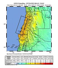
English: Shake map of the magnitude 8.8 earthquake offshore Chile on February 27, 2010. Epicenter marked at star. Seventh version of the map, realized by USGS on 5 March 2010 at 03:00:13 AM MST. |
| Tarih | |
| Kaynak | USGS |
| Yazar | USGS |
| Kamera pozisyonu | | Bu ve diğer görüntülerin konumlarını şurada belirle: OpenStreetMap |
|---|
Lisanslama
2010 Maule earthquake intensity USGS.jpg adlı görüntü kamu malıdır çünkü içeriği, ABD İç İşleri Bakanlığı (United States Department of Interior) bünyesindeki bir daire olan Birleşik Devletler Jeolojik Etüd (BDJE; United States Geological Survey, USGS) kökenli özgün malzeme ile ilgilidir.
Daha ayrıntılı bilgi için, bakın: BDJE'nin resmi telif hakkı uygulaması.
|
Dosya geçmişi
Dosyanın herhangi bir zamandaki hâli için ilgili tarih/saat kısmına tıklayın.
| Tarih/Saat | Küçük resim | Boyutlar | Kullanıcı | Yorum | |
|---|---|---|---|---|---|
| güncel | 02.30, 15 Ağustos 2013 | | 612 × 719 (110 KB) | Adelpine | Update to 10th version |
| 21.20, 21 Mart 2010 |  | 612 × 720 (99 KB) | Adelpine | ||
| 17.31, 2 Mart 2010 |  | 612 × 720 (100 KB) | RapidR~commonswiki | update to latest map (v6) | |
| 08.32, 27 Şubat 2010 |  | 612 × 713 (107 KB) | Andreas Willow | {{Information |Description={{en|1=Shake map of the magnitude 8.3 earthquake offshore Chile on February 27, 2010. Epicenter marked at star. Second version of the map, realized by USGS on 27 February |
Dosya kullanımı
Aşağıdaki 3 sayfa bu dosyayı kullanmaktadır: